The first known mention that the Green Hills property could be a possible dam site is as a result of the Queensland Government’s Water Infrastructure Task Force in 1998. The Green Hills site was one of the two options identified for further investigation, of 13 possible water storage options in the Gulf that were subject to preliminary assessment. The Green Hill site was again highlighted in 2001 as part of the Queensland Government’s Natural Resource Assessment and Water Infrastructure Planning Study for the Gulf Region.
The site for the Green Hills dam (Gilbert River immediately downstream of Green Hills station) was again highlighted by the CSIRO Flinders and Gilbert Agricultural Resource Assessment, which identified possible dam locations after assessing published and unpublished literature from the Queensland Government and SunWater archives.
The site was promising based on its favourable geology, relatively high yield, and proximity to soils suitable for irrigation. The Etheridge Shire Council then commissioned Jacobs Australia Pty Ltd to produce a detailed business case for the dam (renamed the Gilbert River Dam). The detailed business case was published in 2020.
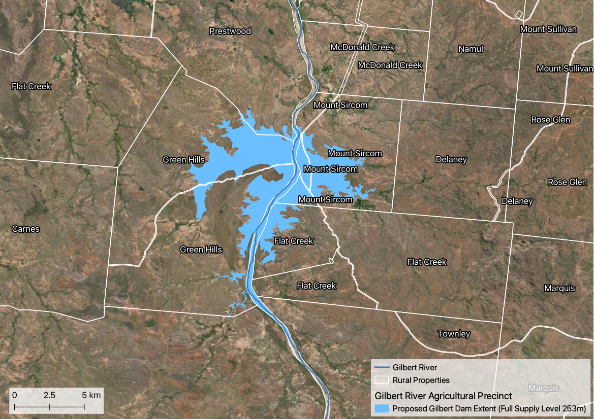
The proposed dam, composed of a main dam wall and several saddle dams, would have a storage capacity of 323,577 ML and inundate an area of 5,847 ha. The inundated area is currently used for cattle grazing, and includes the Green Hills homestead. Total water delivered from the dam would be 130 GL per year. This amount of water is under a third of what is currently set aside in general unallocated reserve for the Gilbert catchment under the Water Plan (Gulf) 2007. Total irrigation area that could be supported by the dam has been estimated at 17,900 ha, comprised of the fertile alluvium soils adjacent to the Gilbert River downstream of the proposed dam site.
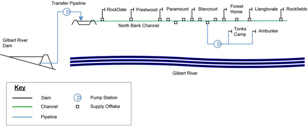
Jacobs Australia Pty Ltd proposed that in addition the main dam site, a transfer pipeline, pump station, balancing storage, main lined channel and customer supply offtakes would be constructed. The distribution network would be north of the Gilbert River, following the Gulf Development Road in parts.
Estimated capital cost of the project was $785 million, including construction cost of the main dam and the delivery network, and water purchase. Annual operating cost and refurbishment cost was estimated to be $5.6 million and $3.8 million, respectively. Annual costs could be be met through annual water charges.
To meet environmental flow objectives set under the Water Plan (Gulf) 2007 the proposed dam would need to be able to release up to 136,830 ML per day. The dam, if built, would inundate ‘of concern’ vegetation and likely impede the movement of several fish species. An environmental impact statement would still need to be completed prior to approval.
Although a dam, or another form of water infrastructure/storage, would support an irrigated agriculture industry in the Gilbert catchment the financial viability of such an industry is largely dependent on the establishment of local processing facilities (e.g., cotton gin). The construction of a large in-stream dam would also rely heavily on government assistance to ensure that water prices would not be prohibitively expensive.
Response from landholders in the area to the proposed dam was mixed, highlighting an independent assessment that addressed social, economic and environmental aspects was favoured by residents before moving forward.
Resources
- Gilbert River Irrigation Project Detailed Business Case linked at bottom of page
- CSIRO Flinders and Gilbert Agricultural Resource Assessment
- Gilbert River Agricultural Precinct
- Etheridge Agricultural Precinct, another recent initiative in the region
- Ecological assets