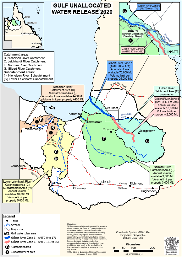
There is a current fixed price water release from unallocated general reserve in the Gilbert catchment managed under the Water Plan (Gulf) 2007. The Gilbert River Agricultural Precinct falls within both Zone 6 from AMTD 171km-368km and the unzoned area. The unzoned area includes unzoned watercourses, or overland flow.
The release currently limits a new license to 2,000 ML per property and the total volume for this section of Zone 6 to 10,000 ML. Water can be taken from the Gilbert River when flow in the Gilbert River at Rockfields exceeds 2,592 ML/day. Additional volumes of water can be made available through other mechanisms in the Water Plan
Conditions for taking water from the release
Several conditions apply for taking water from this release. The developable land must be free of vegetation management constraints and suitable for irrigated agriculture. The proposed development must be ecologically and culturally sensitive.
The expectation is that landholders entering into or expanding irrigation will commence activities as soon as they have secured water and there must be a demonstrated intention to use water within 3 years of obtaining the water licence. This intent can be demonstrated by physically taking water or at least having constructed infrastructure capable of taking water.
The chief executive may also decide some conditions specified in the Terms of release including the installation of a working measuring device (with telemetry capabilities) to measure the volume of water taken.
Development approvals are also required for taking water from a watercourse and waterway barrier works.
Application Form
The Application Form is available as Schedule 2 within the Terms of release. It includes:
Part A: Applicant details
Part B: Specify the minimum and maximum volume of water being sought and the payment option
Part C: This section of the schedule specifies the water source (e.g. the Gilbert River Zone 6 for river take or the Gilbert catchment for overland flow), the lot/plan where water is to be taken, existing works (if applicable) and the lot/plan where the water is to be used.
A map is to be attached that shows, where available,the location from where water will be taken, the intended irrigation area, the location of infrastructure (e.g., pumps, channels, storages, irrigators), the dimensions and construction details of infrastructure and existing water resource developments.
Also to be attached is a statement outlining how the water infrastructure will operate, how the water will be used on the land, if other water sources currently exist how they will be used in conjunction, and the proposed timeline of development.
Part D: Declaration
Resources
- Gulf unallocated water release on the Business Queensland website
- Terms of release
- Gulf water availability map
- Further information: waterinfonorth@rdmw.qld.gov.au
On this website:
- Development approvals
- Stream gauges, including Gilbert River at Rockfields
- Water management
- Water availability
- Policy prompt packs, for facilitated discussion of policy processes