The Queensland Water Modelling Network 2021-2022 Digital Twin project used “policy prompt packs” drawing on the digital twin to facilitate conversations about regulatory processes.
The policy prompt packs developed for “A farm dam to capture overland flow” and “Take from the Gilbert River” are meant to be used in facilitated discussions with a landholder or group to encourage questions to be asked about both the scenario and the policy process itself.
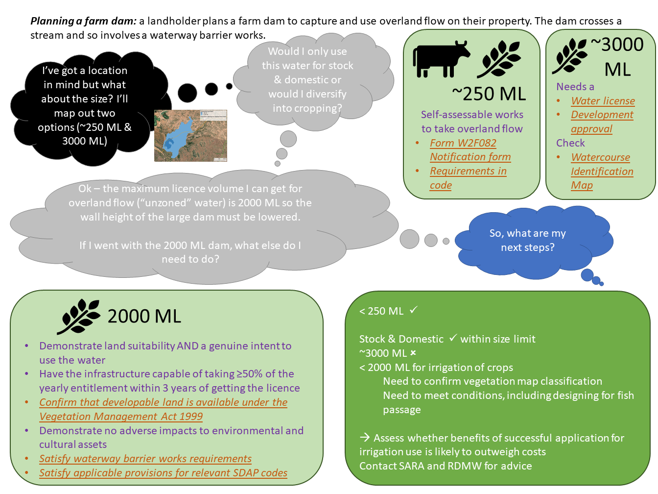
Farm dam
This pack outlines a scenario in which a landholder is exploring their options for building a farm dam to capture and use overland flow on their property. The dam crosses a stream and therefore also involves a waterway barrier works. The policy prompt pack steps through a variety of circumstances for a dam presenting non-binding information about the current policy process.
For a hypothetical property and landholder, options for a hypothetical dam are scoped. Two dam sizes are considered, a small dam less than 250 ML and a larger dam with a 6m wall and which could hold up to ~3000 ML.
By the end of the scenario, the landholder concludes that while a small dam is possible (<250 ML or within stock and domestic maximum capacity limits), the large dam is not possible within the Gulf Unallocated Water Release where the water is from an unzoned area. A dam of intermediate size (<2000 ML) could be possible depending on confirmation of vegetation map classification and subject to conditions, including designing to allow for fish passage.
The next step is for the landholder to assess whether benefits of a successful application for irrigation use is likely to outweigh costs. If they are interested to proceed further, the landholder would then approach SARA and RDMW for advice specific to their case.
Gilbert River
This pack outlines the scenario of a hypothetical landholder planning to take water from the Gilbert River. The landholder wants to understand whether it is a viable source of water given conditions and approvals required to access and use this water.
By the end of the scenario, the landholder notes that stock and domestic water use may not need a water licence or development application for taking or interfering with water. Other local and state planning triggers may apply, and the landholder would need will check with the local council and SARA in case other triggers apply.
For agriculture, the limits on water volumes and timing of take mean that the landholder would likely need to plan for storage of water for use when needed. The assessment process for a landholder may be fairly smooth if water is to be taken at times with large water flows, few other landholders have applied for licences, and there is a clear location for use and storage of water with limited impact, notably because vegetation has already been cleared. However, if the landholder plans to take water in conditions with high risks of impact, then assessments may be more expensive.
Once the landholder has a rough plan in mind, the next step is therefore to contact Water Info North for a pre-lodgement meeting.
Resources
For access to the policy prompt packs, contact Gulf Savannah NRM, regarding the 2022 Queensland Water Modelling Network (QWMN) Digital Twin project