Custodianship
The Tagalaka and Ewamian peoples are the custodians of the land and waters in the Gilbert River Agricultural Precinct.
Read More
Development Approvals
Development approvals allow a proponent to undergo some kind of development. Development approvals are granted once a developmemt application has been assessed by the relevant agencies.
Read More
Ecological assets
Ecological assets in the Gilbert River catchment include vegetation, fauna, waterhole ecosystems, floodplains, and wetlands. Flows from the catchment also support an established fishing industry in the Gulf. It is likely that development of the catchment would impact the area's ecological assets; further impact assessment is required.
Read More
Erosion
Erosion is a natural process where soil or rock is removed. Erosion can be accelerated by human activities (e.g., grazing, agriculture). Erosion is a current problem in the Gilbert catchment and should be addressed before any further land use change.
Read More
Etheridge Shire Agricultural Precinct
Proposal Overview
The Etheridge Shire Agricultural Precinct proposal aims to create ‘an agricultural and water precinct of State significance’ that would establish protocols and preapprovals relating to tenure, water allocation, vegetation management, native title future acts and cultural heritage’. As a coordinated project, this proposal would target the general unallocated water available under the Water Plan (Gulf) 2007 (see Water Management).
Farm dams
...
Read More
Flooding
Stream and river crossings flood during the wet season, and high flows may flood surrounding areas.
Read More
Gilbert River
An overview of the Gilbert River between Green Hills and Chadshunt stations, including characteristics of the bed sands and data sources
Read More
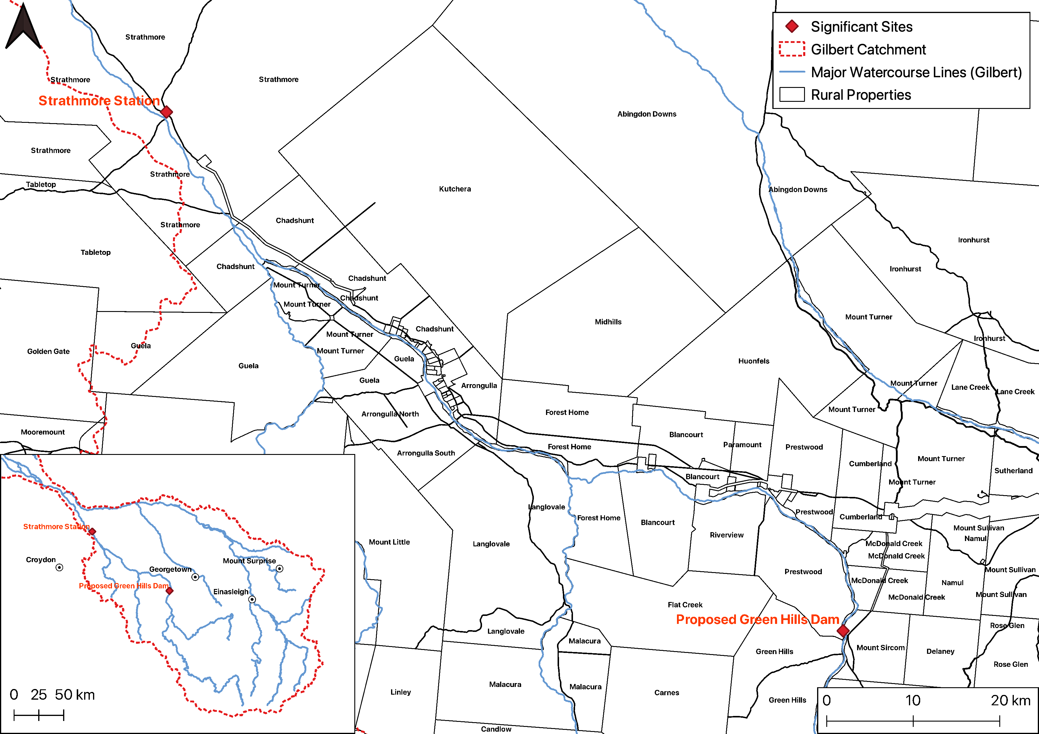
Gilbert River Agricultural Precinct
The Gilbert River Agricultural Precinct (GRAP) incorporates the properties along the Gilbert River between Green hills and Starthmore Station. This area has been continuously highlighted as having potential for irrigated agriculture based on soil properties and water availability, but little progress has occurred to date.
Read More
Proposed Green Hills Dam
The proposed Green Hills dam, an in-stream dam on the Gilbert River, was the focus of a detailed business case published in 2020. The dam, if built, would service the Gilbert River Agricultural Precinct, expanding irrigated agriculture in the area.
Read More
Groundwater
Groundwater is an important resource in the GRAP, with bores being used for stock and domestic use and a limited number of spear bores accessing water stored in the bedsands of the Gilbert River. Along with surface water, groundwater could be used to expand irrigated agriculture in the region.
Read More
Gulf Unallocated Water Release
Unallocated water to support irrigated agriculture and economic development opportunities in the Gilbert catchment.
Read More
Runoff
Runoff is fallen precipitation that moves across the land surface. Runoff can be estimated using models. Runoff in the Gilbert catchment is concentrated in the wet season and varies depending on the severity of the wet season.
Read More
Soils
There are abundant soils suitable for irrigation throughout the Gilbert catchment, particularly adjacent to the catchment's major rivers. Previous work has used both soil and climate data to gauge land suitability of numerous crops.
Read More
Stream network
...
Read More
Surface Water
Surface water includes any water that is above the ground. Surface water in the north of Australia is influenced by the monsoonal climate, with many water bodies and watercourses being ephemeral. Those that are not ephemeral become refugees for flora and fauna in the dry season, or become watering points for cattle.
Read More
Vegetation Management
Development needs to ensure high value land is cared for. While landholders often care for the land themselves, government also imposes specific land clearing rules.
Read More
Vegetation
Vegetation, an assemblage of plant species, can be classified in many ways. How vegetation is classified has policy implications. Weeds are an issue in the northern Australia.
Read More
Water availability
In a monsoonal climate there is need to capture and store water in the wet season for use in the dry season. For year round irrigated agriculture to operate storing water is essential. However, altering flow patterns is not with impacts.
Read More
Water bodies
Water bodies flood in the wet and provide water into the dry, including farm dams, water holes, and wetlands and lakes.
Read More
Water budget
...
Read More
Water infrastructure
Water infrastructure allows for the storage, diversion, supply and treatment of water. Water storage is limited in the Gilbert catchment compared to more agriculturally developed regions of Australia. Proposed developments and current water releases have a strong focus on progressing water infrastructure in the region.
Read More
Water management
Access to available surface water or groundwater is defined by the water source (surface water / groundwater) and the intended use of the water (e.g. stock and domestic, irrigation, prescribed activities).
Read More
Watershed / Catchment
A catchment is an area that collects water, defined by the areas topography. A catchment is made up of subcatchments, which are themselves made up of subcatchments. Many models depend on defining a catchment.
Read More
Weather
The climate in the Gilbert River has a distinct wet and dry season, with evapotranspiration more then doubling rainfall on an annual basis.
Read More